現在,您可以從任何地方駕車環游洛杉磯的各個社區,全程 36 公里(22 英里)。
截至目前,仿真公司rFpro已經繪制了全球180多個地點的數字地圖,其中包括公共道路、測試場地和賽車賽道。然而,這些地圖的規模及復雜程度都比不上該公司最新推出的一款數字地圖。rFpro技術總監Matt Daley在AutoSens USA 2024上稱,這款新推出的洛杉磯數字地圖是一個“無比巨大且復雜的數字模型”,覆蓋了一條全長36公里(22英里)的雙向行駛環形路,用戶可在其中虛擬駕駛。其中的數字道路是使用勘測級激光雷達數據在1cm×1cm(1.1″×1.1″)的X-Y網格上構建的,地圖中還包含超過12000棟路邊建筑物、13000個街道基礎設施(如交通標志和路燈)和40000株植被。
Daley表示,“這是一個絕佳的地點,其中包含了大量不同類型的基礎設施,對自動駕駛汽車而言極具挑戰性。在這條環形道路上駕駛時,您可以測試所有輸入的車輛參數,并體驗懸架系統。尤其對于自動駕駛汽車而言,傳感器受到的震動與您在真實道路上駕駛時的體驗幾乎一致。”
這款數字地圖覆蓋的是洛杉磯西南部的一塊區域,包括110號高速公路從洛杉磯港到卡森市的路段,穿過了托倫斯工業區、密集住宅區和郊區的羅靈丘陵。對于那些想要進行多種模擬測試(尤其是自動駕駛系統測試)的公司而言,這個多元化的新模型具有極大的價值。
Daley表示,“我們現在可以在各種日常場景中對自動駕駛汽車進行測試,包括不同的環境、交叉路口和道路類型”。他補充說,數字地圖數據集還包含鐵路道口、加油站、十字路口以及高速公路的上下匝道等數據。
Daley告訴SAE:“自動駕駛汽車在研發時面臨的一大挑戰是必須獲取大量多元化數據,然而在真實道路測試中很難做到這點,因為這需要行駛大量的里程、覆蓋許多不同地點,并累積足夠的數據才能做到。而仿真測試則不同,我們可以直接創建多元化場景,也可以讓客戶在現有數字地圖上添加次級的多元數據。”
rFpro于2007年成立并進入駕駛員在環仿真,從2015年開始考慮集成ADAS測試。
Daley指出,“我們意識到,憑借我們為構建可靠的仿真平臺和基礎設施投入的資金,以及我們創建3D模型的技術和能力,我們便可以添加新的數據層。我們知道這樣做就等于改變了產品的性質,而且必須賦予新模型新的功能,因為它的應用領域將不限于有人駕駛場景。我們必須在該模型上添加數字攝像頭,但攝像頭不同于人眼,它們通常在不同的時間段對周圍環境進行采樣。而且,我們還需要使用雷達模型和激光雷達模型,因此我們創建了傳感器API系統,以便對插件進行建模,并將其作為額外通道集成至仿真模型中。”
無論是人類駕駛員還是虛擬駕駛員,在rFpro地圖中看到的場景都是由相同材料構成的幾何世界。人類駕駛員可以看到由每像素8位的RGB顏色構成的虛擬世界,而模擬攝像頭可能會處理“通過感知系統傳遞下來的更高位圖像。但虛擬世界的基本原理和其中物理學的計算方式是相同的,關鍵在于如何以正確的格式展現傳感器需要看見的圖像,” Daley表示。
rFpro控股公司AB Dynamics PLC于2022年收購了Ansible Motion,后者不僅提供3D全動態平臺硬件,還提供完整的集成解決方案。Daley表示,“除了Ansible外,我們有一些合作伙伴或經銷商也將“rFpro地圖”集成至其自身硬件上。同時,我們的很多客戶也會自己集成。比如,早在2014年我還是法拉利的客戶時,我們對法拉利自主研發的模擬器進行了改裝,并將rfPro地圖整合進了模擬器,通過升級現有系統,使其具有更高的保真度。為什么這一點很重要?因為客戶可以利用我們的仿真模型創建成幾十萬個不同邊緣場景的不同測試,也可以利用這個基于真實地點構建的復雜高精度模型,重新創建一些在現實世界中可能發生的已知風險事件。”
Daley表示,憑借rFpro系統,客戶可以生成一些在現實中未曾發生,且實際駕駛中難以遇到的邊緣場景。這是因為在現實世界中,客戶沒有足夠的時間、金錢、資源和車輛,或是純粹的運氣來滿足這些邊緣場景所需的特定天氣、車輛或行人等條件的組合。而這個洛杉磯數字地圖是基于真實地點創建的,因此你可以在仿真模型和真實地點之間進行匹配性測試,以建立仿真模型的置信度,這有助于提升你利用合成訓練數據的能力。
rFpro新推出的洛杉磯數字地圖即可應用于駕駛員在環實時駕駛,也可用于全保真光線追蹤模擬器以生成復雜的高保真度感知數據,并在短時間內提供數萬次測試。此外,數字攝像頭也可以用于模擬帶運動模糊圖像的邊緣場景,或具有完整連拍效果的邊緣場景(不同的OEM可以為其傳感器定義不同的參數)。Daley表示,“該數字地圖不僅生成了自動駕駛系統所需的最高保真度的訓練數據,而且是利用行業領先的感知融合技術構建的,因此可與這些技術協同運作。”
總之,洛杉磯數字地圖是rFpro基于現實世界繪制的最好的地圖,它可以使自動駕駛技術公司相信,他們在仿真模型中得到的結果具有現實意義。
Daley表示,“只有在相信模擬結果的前提下,你才能實現這一目標。如果仿真模型是采用虛構地點創建的,那么就很難將仿真結果與現實情況聯系起來。基于真實地點創建的仿真模型具有很大的價值,能夠讓我們有信心擴展仿真應用的規模。”
Simulation company rFpro has already mapped over 180 digital locations around the world, including public roads, proving grounds and race circuits. But the company’s latest is by far its biggest and most complicated. Matt Daley, technical director at rFpro, announced at AutoSens USA 2024 that its new Los Angeles route is an “absolutely massive, complicated model” of a 36-km (22-mile) loop that can be virtually driven in both directions. Along these digital roads – which were built off survey-grade LIDAR data with a 1 cm by 1 cm (1.1-in by 1.1 in ) X-Y grid – rFpro has added over 12,000 buildings, 13,000 pieces of street infrastructure (like signs and lamps), and 40,000 pieces of vegetation.
“It’s a fantastic location,” Daley said. “It’s a huge array of different types of challenging infrastructure for AVs. You can drive this loop with full vehicle dynamic inputs, ready to excite the suspension and, especially with AVs, shake the sensors in the correct way as you would be getting if you were driving those real roads.”
The new digital map covers an area in southwest LA that includes Highway 110 from the harbor up to Carson, going through industrial areas, dense residential areas in Torrance, and suburban Rolling Hills. The variety is what makes this new model so valuable to companies that want to simulate various tests, especially for new automated driving systems.
“We are now able to give autonomous vehicles the ability to test in all of these different types of environments, junctions, and road types that they’re going to experience in day-to-day life,” Daley said, adding that there are railroad crossings, gas stations, intersections, and highway on- and off-ramps in the data set.
“The grand challenge of autonomous development is that you need so much diversity available to you,” Daley told SAE Media. “It’s extremely difficult to get in the real world, because you have to go so many different miles, so many places, and really drive so much volume in order to create it. It’s a slightly different challenge in simulation, because we can create diversity and let people create second levels of diversity inside existing maps.”
Not just for human drivers
RFpro started in 2007 in the driver-in-the-loop market. In 2015, the company started to think about how to integrate ADAS testing.
“We realized that the amount of investment that we got in providing a solid simulation platform and infrastructure, as well as our technologies and abilities to build 3D models, we could add additional layers,” Daley said. “We knew it wouldn’t be the same product, we had to keep adding additional functionality because it was no longer just humans that were looking into this. We had to add digital eyes, and cameras are not human eyes. They are different in the way that they sample the world over different time periods. And then [we needed] lidar and radar models as well, so we created the sensor API system to allow plugins to be modeled, and to come and sit in as additional channels in the simulation.”
No matter if a human or a digital driver is viewing the scene in an rFpro map, it uses the same geometric world, Daley said, including what all the materials are made of. Humans will see the virtual world displayed with an eight-bit RGB color per pixel, but a simulated camera might process a “higher-bit image that gets passed on through a perception system down the chain,” Daley said. “The fundamentals of the world and how you calculate the physics in the world are still the same. It all comes down to how do you present that onwards in the correct format for how the sensor needs to see.”
AB Dynamics PLC, which also owns rFpro, acquired Ansible Motion in 2022. Ansible provides 3D full-motion platform hardware and can do full integrated solutions, Daley said. “We have other partners and other resellers that integrate [our maps] onto their own hardware,” he said. “A lot of our customers do it themselves as well. I was a customer at Ferrari back in 2014, when we converted an in-house simulator they had and brought rfPro onboard and upgraded an existing system with a higher fidelity world. And why does this matter? Well, it’s the virtual playground that allows our customers to create hundreds of 1,000s of different tests of different edge cases and to recreate some of the known hazardous events that can happen in the real world in a highly accurate model of a real-world location, with the real world complexities that are there.”
Daley said rFpro’s system also allows customers to “generate things that didn’t happen, that you couldn’t find by doing real-world drives, because you simply do not have enough time, money, resources, vehicles, or the pure luck of finding the combination of weather and vehicles and pedestrians all doing the edge case scenarios that you need. Because [the LA map is] a real-world location, you can also correlate, you can do matching tests in your simulation and your real-world location to build your level of confidence in the simulation that really helps you to exploit the power of using synthetic training data.”
Rfpro’s new LA route can be driven in real-time with a human-in-the-loop driver or used in a simulator with full-fidelity ray tracing to generate complicated high-fidelity sensables, providing tens of thousands of tests in a short time. Digital cameras can also simulate edge cases, with nuances that come from having motion blur in an image or with full rolling-shutter effects that each OEM can define for each of their sensors. “It produces the highest fidelity training data to go into autonomous systems, and it’s built on top of and alongside industry led sensable integrations,” Daley said.
Overall, the LA map is rFpro’s best example of a map based on the real world that can provide automated driving tech companies with confidence that what they find in the simulator will match what might happen in the real world.
“You can only get to that position if you have confidence in your simulation,” Daley said. “It's pretty impossible to correlate your simulation if that thing is not a real location, if you're just making up a location. Having real world locations is hugely valuable to actually give you that confidence to scale.”
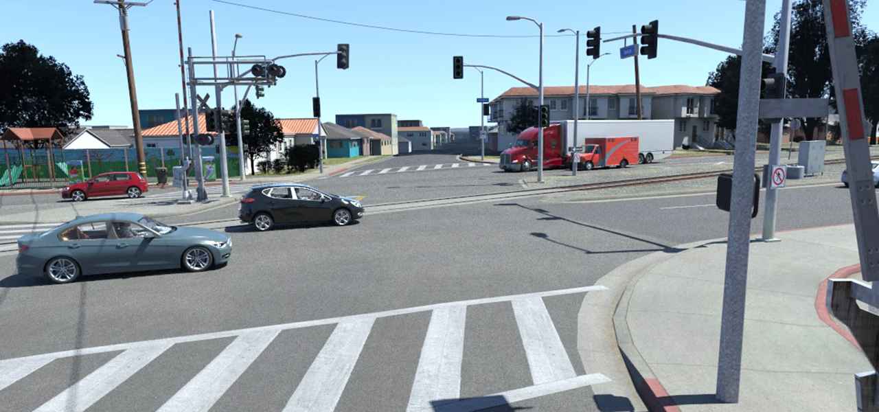 這是rFpro新發布的洛杉磯數字地圖的一個場景,該地圖覆蓋了一條全長36公里(22英里)的雙向行駛環形路。(rFpro)
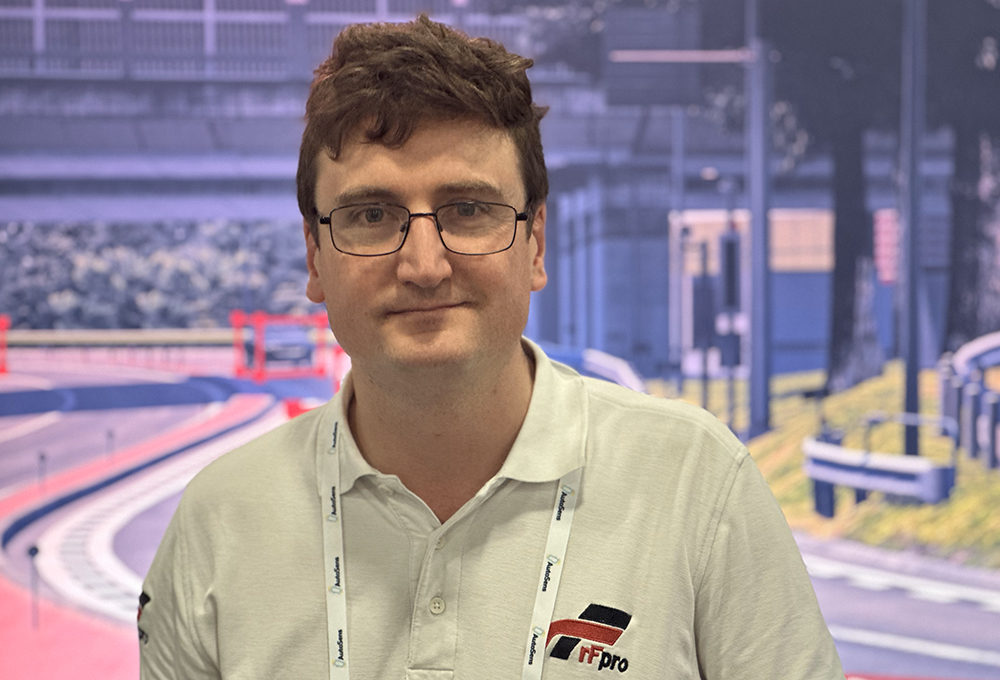 rFpro技術總監Matt Daley在 2024年美國AutoSens展會。(SEBASTIAN BLANCO)
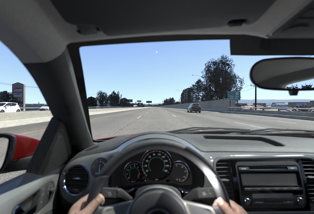 rFpro的新洛杉磯地圖包括12,000多座建筑、13,000個基礎設施(標志和燈具)以及40,000種植物。(rFpro)
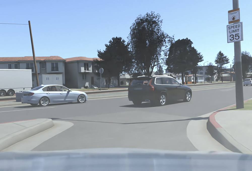 洛杉磯地圖數據集包括各種現實世界變量,如鐵路道口、加油站、十字路口和高速公路上下匝道。(rFpro)