如今,在各種先進技術的支持之下,汽車和卡車的真實工況性能和穩健安全表現都有了大幅的提升。不過,除了常見的高級駕駛員輔助系統 (ADAS)、基于人工智能的機器學習技術、V2V/V2I通信、高分辨率3D街道地圖以及數字雙控制系統外,未來還有哪些技術將逐步突顯,助力自動駕駛汽車的發展呢?
專家認為,新一代GPS(全球定位系統)衛星導航系統有潛力發展成為一種顛覆性技術。該技術可以精準定位車輛或卡車的實時位置,為自動駕駛汽車提供可靠性冗余誤差不會超過5厘米。這種設計很有必要,因為隨著時間的推移,傳感器總有一天會出現某種程度的退化,甚至完全報廢,也正是因為這個原因,汽車設計師總是會在汽車上部署多個傳感器。
一旦“厘米級”GPS系統的成本下降至單價30美元以內,這種技術就可以作為一種有效的可靠性冗余,廣泛應用于大量汽車中。
精確GPS
最近,科技市場分析機構ABI Reserch發布了一份針對超高精度衛星導航技術的預測報告,稱低成本、高精度的GPS/GNSS(全球導航衛星系統)接收器可能將很快成為現實。
ABI公司首席分析師PatrickConnolly表示,到2021年,精密GPS將逐步登陸無人駕駛汽車、無人機,甚至智能手機。
“現在,汽車行業正在評估比較各種相互競爭的技術,但我們認為未來的汽車行業將逐步采用一種混合性措施,也就是說混合采用傳感器、傳感器融合和精確GNSS系統。”Connolly指出,“考慮到現階段GPS接收器的單價已經下降至50美元以下,我們認為,未來的定位技術服務市場將得到一定發展,比如一些中高端車型內采用的人工現實和抬頭顯示器等。”此外,V2V通信也有可能有力推動自動駕駛汽車的發展。
Connolly表示,GPS只是作為備用,并不是主傳感器。精密衛星導航功能預計可以提供可靠性冗余,為自動駕駛汽車的安全系統提供有力補充。Connolly指出,當然了,全球定位系統(GPS)也有一些自身固有的問題,比如信號阻塞、多路徑干擾等等,但如果價格合適,這種定位系統絕對可以成為SAE 4級和5級自動駕駛車輛的有力助手。
GPS的工作原理
簡單來說,GPS/GNSS衛星將按照設定軌道環繞地球運行,并向地面傳送衛星和信號信息。接著,GPS接收器將接收到這部分數據,并利用“三邊測量”的方法計算用戶位置。
從本質上講,GPS接收器可以比較信號的發送和接收時間,而后利用這種時差,或者說是“飛行時間”計算衛星的距離。GPS系統將從至少4顆衛星接收測距數據,其中3顆用于定位,1顆用于確定接收器的時鐘偏移。
奧斯丁市德克薩斯大學副教授、該校無線電導航實驗室主任Todd Humphreys表示,大多數手持GPS接收器均使用單頻GPS信號,可以將定位誤差控制在3m之內,而商用級映射接收器的誤差大約在1m之內。
Humphreys教授解釋說,測量級差分定位系統的精度最高,在工作時需要基站和探測器的支持,至少需要從4顆衛星接收信號。
Humphreys表示,即使附近沒有基站,雙頻接收器仍可以通過一種名為“精準單點定位”的技術,綜合利用精準衛星鐘差、輔助“歷元間”分析及電離層狀態模型等外部信息,將精度控制在厘米級別。
Humphreys解釋道,“但問題是,精準單點定位的效率很低,大概需要幾十分鐘才能收斂不到10CM的區域。”另一種定位方法是RTK定位。
傳感器協助
ABI的Connolly指出,精密GNSS系統可通過多種手段將精度控制在1m之內,其中包括利用一個參考站網絡。他表示,現階段最大的問題并不是成本,而是“如何利用參考站提供的補充位置信息或其它來源,支持RTK或PPP定位的修正,進而實現可靠衛星導航系統的全球覆蓋。這項工程耗資巨大,目前并無法看到清晰的投資回報。
工程師和技術人員想知道傳感技術優化的潛力,以及這能將怎樣減輕車輛自動控制系統在機器學習方面的負擔。“如果你能用到更好的傳感技術,你就能更輕松地解決更多與ADAS技術有關的問題。”Humphreys表示,舉個例子,如果出現雨雪、大霧遮擋道路標記或道路邊沿,甚至是在夜間視野不佳的情況,車輛的傳感器和圖像識別系統均有可能表現不佳。
Humphreys表示,下一代GPS就相當于地面上的“儀表飛行”技術”。除了成本更低外,“GPS系統的另一大‘優勢’就是能夠極大地減少這些系統計算修正所需的時間。”
去年,德州大學奧斯丁分校的創業公司Radiosense展示了精密衛星-導航定位系統在智能手機上的應用,獲得了三星的項目支持。不過,Humphreys表示,這種解決方案很“脆弱”。
公司團隊使用了多種復雜的信號處理技術,來處理數據輸入并降低源自多路信號與射頻信號阻塞的誤差。目前,這家公司正在測試一款低成本的車道偏離預警系統,該系統可以從分布在市內多個位置的十幾個基站獲得實時修正。
下一代預測性GPS
如今,定位技術領域的競爭非常激烈,各路選手同場競技,既有眾籌創業公司,也有谷歌和阿里巴巴等互聯網巨頭。ABI公司稱,目前的主要選手包括精密接收器供應商NovAtel、天寶導航(Trimble Navigation)、消費接收器制造商u-Blox、Skytraq Broadcom、高通(Qualcomm)意法半導體(ST Microelectronics),以及創業公司North Surving、NVS技術、REACH和SwiftNavigation公司。
舉例而言,總部位于加州的Swift Navigation公司剛剛發布了最新Piksi Multi GNSS接收器。公司業務發展副總裁Rob Hrance表示,這款基于軟件定義的接收器支持雙頻操作,能夠以較低的成本提供快速RTK收斂和可靠的“厘米級”精密定位服務。
另外,一家名為EXO Technologies的以色列創業公司則開發了一種基于軟件的技術。公司聯合創始人及首席營銷官Isaac Zafarani稱,這種技術能夠進行預測性修正,從而降低系統對互聯功能的依賴,避免產生額外的計算量。他表示,EXO設備提供的衛星定位數據更方便,也就是說收集時間更短。
“我們絕大部分的GPS接收器均應用了實時修正,因此可以將精度控制在5到10cm。”Zafarani表示,“另外,我們的數據可通過互聯網提供,支持全球覆蓋。”
The list of technologies that could deliver the expected level of real-world performance and safety for robotic cars and trucks is long. Beyond today's advanced driver assistance systems (ADAS), artificial intelligence-based machine learning, V2V/V2I communications, high-definition 3D street maps and digital-twin controls, what other technologies will find their way aboard the autonomous vehicle?
Next-generation GPS (Global Positioning System) satellite navigation technology that can reliably and precisely locate a car or truck within around 5 cm (1.9 in) in real-time, could be a game-changer, providing back up, experts believe. That's because over time sensors will at some point deliver a degraded return or fail entirely. Vehicle designers deploy multiple technologies for this reason.
Should the cost of centimeter-accurate GPS location drop below $30 per unit, it could provide effective, reliable redundancy on a high-volume basis.
Pinpoint GPS
Such low-cost, precision GPS/GNSS (global navigation satellite system) receivers are nearly at hand, according to tech market analysts ABI Research, which recently issued a forecast on super-accurate sat-nav technology.
By 2021, precision GPS will begin to find its way into driverless cars, drones and even smartphones, said Patrick Connolly, principal analyst at ABI.
“Various competing technologies are now under investigation by the auto industry, but we believe that it will move to a hybridized approach, combining multiple sensors, sensor fusion technology and precision GNSS,” Connolly noted. “As the receivers’ unit price drops below $50, we expect to see a market develop for location technology services, such as artificial reality and head-up displays in higher-end vehicles.” V2V communications is another probable application.
GPS is not the primary sensor, but the back-up, he said. Precision sat-nav capabilities are expected to provide the essential redundancy to complete the safety systems for autonomous vehicles. Of course, GPS has its own inherent intermittency problems: signal blockages, multipath interference and so forth, Connolly pointed out. But if the price were right it could be an invaluable addition to the technology arsenal required for SAE Levels 4 and 5 driving.
How GPS works
GPS/GNSS satellites circle the earth in well-defined orbits and transmit satellite and signal information to the ground. GPS receivers take this data and use a "trilateration" process to calculate the user’s location. Essentially, the GPS receiver compares the time a signal was transmitted with the time it was received.
The time difference, or "time-of-flight," tells the GPS receiver how far away the satellite is. With distance measurements from at least four satellites—three for position and one to estimate any offset in the receiver’s clock—the receiver can triangulate the user’s position.
Most handheld GPS receivers use single-frequency GPS signals to achieve accuracies of about 3 m (10 ft), whereas commercial grade mapping units get within about a meter (39 in), according to Todd Humphreys, associate professor at the University of Texas at Austin and director of its Radionavigation Laboratory.
The most accurate type of GPS system, a differential survey-grade location system, requires a base station and a rover, each of which must receive signals from at least four satellites, he explained. Survey-grade GPS units, which are typically dual-frequency, have accuracies within 1 cm (.39 in) horizontally and 2 cm vertically, but cost $1,000 to $2,000 and more.
If no base station is nearby, Humphreys said, dual-frequency receivers can still achieve centimeter-level positioning via a technique called Precise Point Positioning, which integrates external information such as precise satellite clock timing, ancillary "ephemeris" predictions and a model of the current state of the ionosphere.
“The catch is that PPP can take tens of minutes to converge to a sub-10-cm solution,” Humphreys explained. Another such approach is real time kinematics (RTK).
Sensor assistance
ABI's Connolly noted that precision GNSS achieves sub-meter accuracy through a variety of methods, including a network of reference stations. He said the biggest question mark today is not cost-related. Rather, it is "how to achieve reliable, worldwide satellite navigation coverage using supplementary location information from reference stations or other sources to support correction techniques, such as RTK or PPP methods. This is a costly undertaking, currently with no guarantee of a return on investment, he said.
Engineers and technology researchers are interested in how far they can improve sensing to reduce the burden on the machine-learning aspect of the autonomous control systems in vehicles. “If you can cheat with better sensing, you can more readily solve many problems with ADAS technology,” noted Humphreys. Sensors and image recognition can perform poorly, for example, if lane markers or road margins are obscured by rain, snow or fog, even nighttime.
Next-gen GPS would be something like instrument-flying on the road, Humphreys indicated. Beyond much lower device cost, “the other ‘miracle’ would be to greatly decrease the time it takes for these systems’ calculations to converge to a corrected solution.”
Last year UT Austin’s own start-up Radiosense demonstrated precision sat-nav positioning on smartphones in a project supported by Samsung. The solution was "fragile," however, Humphreys reported.
The team uses sophisticated signal processing techniques to process the incoming data and reduce the errors that derive from multipath signals and RF signal blockage. Current testing involves a low-cost vehicle lane departure warning system that receives real-time corrections from a network of a dozen base stations set around town.
Next-gen predictive GPS
Competition in the location technologies segment ranges from crowd-funded startups to Internet giants Google and Alibaba. The cast includes precision receiver vendors NovAtel and Trimble Navigation, consumer receiver makers u-Blox and Skytraq Broadcom, Qualcomm and ST Microelectronics, and start-up firms such as North Surveying, NVS Technologies, REACH and Swift Navigation, ABI reported.
California-based Swift Navigation, for example, just introduced its Piksi Multi GNSS receiver, said Rob Hranac, vice president for business development. The software-defined receiver’s dual-frequency operation offers rapid RTK convergence times and reliable, centimeter-accurate positioning results at an increasingly affordable price, he stated.
An Israel-based start-up called EXO Technologies has developed software-based technology that generates corrections in a predictive manner, thereby reducing the dependency on connectivity and the need for additional computations, said Isaac Zafarani, co-founder and chief marketing officer. EXO’s device delivers better satellite position data, he claimed, which means faster acquisition time.
“Corrections are applied in real-time to most GPS receivers, resulting in 5- to 10-cm [up to 4 in] accuracy," Zafarani said. "And our data is provided through the internet, enabling global coverage.”
Author: Steven Ashley
Source: SAE Automotive Engineering Magazine
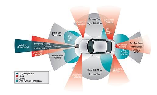 在許多無人駕駛原型車中,攝像頭、激光雷達和雷達組將協同工作,提供支持安全冗余的360°傳感。
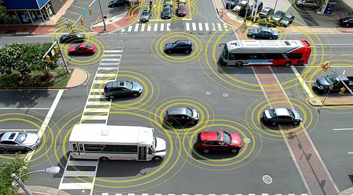 如今,V2V和V2I通信系統的優化將助力超高精度GPS系統的發展。
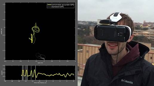 2015年,德克薩斯大學奧斯汀分校的工程師展示了精密“厘米級”GPS全球定位軟件在智能手機上的應用,用戶可通過虛擬現實頭盔觀看3D地圖。
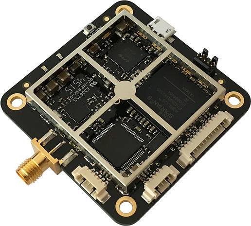 Swift Navigation公司基于軟件定義的新型Piksi Multi雙頻GNSS接收器,可以提供快速的“厘米級”定位服務,公司稱這款產品的成本不高。